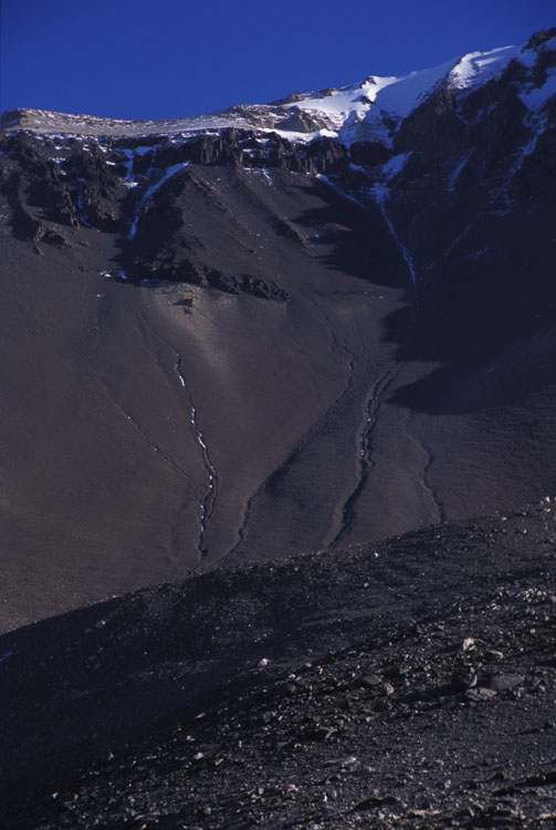
I couldn't quite figure out the channels seen in this picture of the Kukri Hills. They had large levees and the particle size in the "bed" was larger than the surrounding rocks in and beyond the levee. There was an absence of fine material in the bed suggesting that it was either transported downslope (but there was no fan of it at the bottom) or transported into the slope like with frost wedges. I would surmise that these channels aren't streams in the traditional or seasonal sense - with the water doing the work of transporting sediment. Rather what little meltwater the slope sees each year collects in the channel and provides the moisture necessary for frost wedging to occur.
The night before I was scheduled to fly back to McMurdo, I went for a walk up the Kukri Hills. My objective was to get as high as I could. The stats: At 1 a.m. I left our lake at 495 m elevation (down and to the left of this picture). By two I was 1.3 km away and 527 m higher. On this picture that is about where the channels disappear behind the foreground. By 3:15 I was up to 1305 m and 1.7 km from the lake. At 4, when I turned around, I was 2.0 km from the lake and a full 1039 m higher at 1534 m elevation. That's about 1 cm from the top of the basalt sill in the upper left corner of this picture. Considering that there is a fairly sizable flat portion in the middle of the slope (between 1 and 2 a.m.), corresponding to a bench created by the glacier (probably Pleistocene and earlier), this was a steep scramble. From 2 to 4 a.m. I did 755 horizontal meters to 512 vertical: that's an average slope of 42.7 degrees. The rocks were essentially at the angle of repose the entire way, making it rather difficult to walk. Actually I wouldn't say there was any walking involved, it was all scrambling.