Quiz 4 Review
The fourth quiz will cover Chapters 11-15. The format will be similar to previous quizzes with the exception of one
longer essay. Below you will find a list of topics that we've covered since the last quiz (in varying levels of detail). Most of the list was compiled by Dolly Freidel. After the list of concepts and terms you will find some
sample questions.
Concepts and Terms that may be on the exam
Soils
5 soil forming factors: parent material (rock that the soil weathered from), climate, topography, biologic activity, and time.
What soils are found on the campus?
Soil Properties: Color, Texture, Structure, Consistence, Porosity, Moisture
Fluvial Geomorphology
base level
longitudinal profile tends to be concave up
drainage basin
Size of particle eroded, transported, and deposited is a function of velocity of fluid (includes water or air) Therefore, the higher the velocity, the larger the particle that can be picked up and moved.
Velocity of water is controlled by: slope of channel bed, roughness (slows water down), shape of channel bed (wide & shallow [slower] versus narrow & deep [faster])
Stream Channels
Erosion, transport, deposition
Sediment carried by suspension, saltation, traction (dragging, rolling along
bottom)
Discharge, velocity, slope, roughness, sediment load
Sources of roughness: size and sorting of rocks in channel bed, sinuosity of channel, vegetation dipping into flow, etc.
Types of sediment load: coarse (boulders, cobbles, gravel) or fine (sand, silt, clay)
Base level, level below which water cannot erode valley (e.g. sea level)
Channel Patterns
Meandering streams
Single sinuous channel
carries fine suspended sediment load in narrow, deep channel
Very low gradient, slope
Tends to be stable, meanders migrate gradually
Landforms: Cutbank, point bar, oxbow lake, floodplain
Associated with moist year round climates, chemical weathering, fine sediment
Braided streams
Multiple channels divided by sand/gravel bars
Wide and shallow channels
Steeper slope than meandering channels
Carries coarse sediment such as sand, gravel as bedload
Tends to be unstable during floods
Associated with dry climates, cold climates, physical weathering, coarse sediment
Fluvial Landforms and Hydrology
stream terraces form along the sides of rivers as the river migrates back and forth across its valley.
deltas form where rivers enter oceans or lakes and deposit sediment
alluvial fans (e.g. the
Cotati alluvail fan)
playa
floods
river management (Colorado River, Mississippi), New Orleans.
Wind (Eolian) Processes and Landforms
Wind erosion and transport: suspension, saltation, rolling and dragging
Wind Erosion - by deflation (removing sediment from a surface) and abrasion (sandblasting)
Types of erosional landforms: deflation hollows, depth controlled by water table; ventifacts; yardangs [sphinx]; desert pavement
Types of depositional landforms: dunes [e.g. barchans, transverse dunes]
Coastal Processes and Landforms
littoral zone - where the interesting geomorphology happens
tides are caused by the moon and sun pulling on Earth's oceans
waves are the primary energy source for coastal geomorphology, they get their energy from the atmosphere (wind, storms)
wave refraction focuses wave energy on the headlands
headlands tend to be erosional (high energy, high relief), coves tend to be depositional (low energy, low relief)
beach profile
longshore/littoral drift
erosional features: cliffs, wave-cut platforms, terraces, landslides, rockfalls, sea caves, arches, sea stacks
depositional features: barrier islands, beaches, spits, lagoons
human impacts
coral reefs, atolls
Glaciers
snow accumulates and compacts over time and under pressure into ice, when the ice starts to move you have a glacier
mass balance: accumulation vs. ablation, equilibrium line
positive m.b. leads to an advancing glacier, negative m.b. leads to a shrinking glacier
ice flow velocities - where is the glacier fastest?
different scales: cirques, valley glaciers, ice sheets
crevasses
Glacial geomorphology
where do glaciers erode? along their beds by plucking and abrasion.
glacial polish, cirques, horns, arete, bergschrund, tarn lakes, roche moutonnee
Where do glaciers deposit sediment? erratics, till, moraines (terminal, lateral, medial), eskers, kettle lakes, drumlins, outwash plains
Periglacial
continuous and discontinuous permafrost, ice wedges, patterned ground, gelifluction
hazards of building in permafrost areas
Glacial History
climate record stored in glaciers, isotopes and glacier lengths
glacial history over the last few million years.
paleolakes, Lake Missoula outburst floods
history over the last few hundred years - Little Ice Age
effects of present-day climate change: increase in meltponds, ice shelf breakups
Acknowledgements
Part of this list of review topics was compiled by Dolly Freidel.
Sample Questions
-
Give an example of a soil property. How can a measurement of that property tell you something useful for engineering or biologic purposes?
-
River flow velocities depend on a number of factors. For each of the following pairs, circle the river characteristic that would lead to a faster velocity.
-
Steep slope, flat slope
-
rough channel bed, smooth channel bed
-
deep water, shallow water (width is the same)
-
lots of vegetation in the channel, no vegetation
-
Draw a map of a meandering river. Show at least one complete bend in the river. Then, using dotted lines or a different writing stick, draw what the river would look like after 50 years (assume humans don't interfere). Explain why the river looks different.
-
The Sacramento River Delta is, in many ways, similar to the Mississippi River Delta near New Orleans. How have human changes to the natural system affected these environments? Give two examples.
-
Describe what happens when waves interact with a beach. Include a diagram of a beach profile (cross-section) illustrating how a beach might erode after starting with a straight angle (like the class demo).
-
Classify each of the following as an erosional or depositional landform (circle E or D) and then give an example of a specific place (like a city) where you might find that landform.
-
spit: E or D
-
wave-cut platform: E or D
-
termimal moraine: E or D
-
cut bank: E or D
-
delta: E or D
-
cockpit karst: E or D
-
alluvial fan: E or D
-
arete ridge: E or D
-
Which of the following factors affect local sea level? Some of these factors act on long timescales (millenia), others on short timescales (seconds).
-
position of the sun
-
position of the moon
-
air pressure
-
water temperature
-
tectonic uplift or subsidence of the land
-
hurricane winds
-
What is the simplest criteria that determines whether a glacier will grow?
-
The glaciers of New Zealand have retreated more than 2 kilometers from their Little Ice Age moraines. What does that tell us about how the climate has changed there in the recent past?
Essay Question
The goal of this essay is to help you synthesize much of what we have learned in this class.
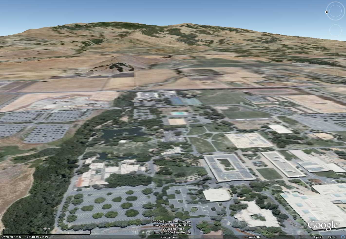
How did
this landscape form? [picture looking east from Sonoma State]. Mention something about each of the following topics.
-
Climate: What are the normal temperatures throughout the year (graph)? When does it usually rain (graph)? Which direction do the winds usually come from? At what times of year do we experience most of our storms?
-
Tectonics: What is the tectonic setting? Where is Cotati in relation to plate boundaries and faults? How did Sonoma Mountain form?
-
Biosphere: What plants and animals are found here? How does the climate affect the biology here? How does the biology affect the geomorphology?
-
Soils: Describe the soils of the Sonoma State University campus. Mention as many of the physical characteristics that you can remember and mention the primary source of the sediment that is now found on the campus.
-
Geomorphology: What are the most important geomorphic processes shaping this landscape? What is the major landform in the foreground of the image? How does the climate affect the geomorphology?
-
Human impacts on the environment: How have humans changed this landscape?